Showing 268 items matching golf course
-
 Whitehorse Historical Society Inc.
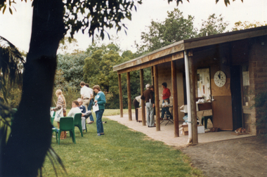
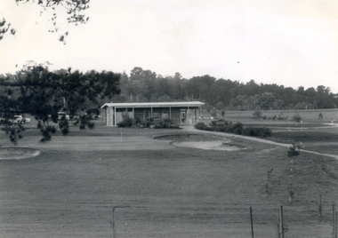
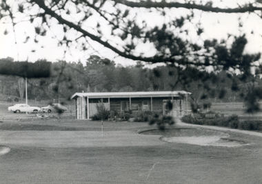
Photograph, Morack Golf Course - clubhouse, 9/11/1986 12:00:00 AM
... Morack Golf Course - clubhouse...morack golf course...Coloured photograph of the Morack Golf Course clubhouse...Morack Golf Course... Mitcham melbourne Photograph Photograph Morack Golf Course ...Coloured photograph of the Morack Golf Course clubhouse taken on 9th November 1986. Taken on a 'Go bush in Nunawading' as part of an initiative of the then Mayor Wendy Reidmorack golf course, city of nunawading, parks and reserves, 'go bush' initiative -
 Apollo Bay Museum
Film - John Verey on the Apollo Bay Golf Course
... John Verey on the Apollo Bay Golf Course...John Verey on the Apollo Bay Golf Course...Golf Course...Audio Slideshow with John Verey on the Apollo Bay Golf... Tsilemanis Apollo Bay Golf Course Oral History John Verey ...Audio Slideshow with John Verey on the Apollo Bay Golf Course. Created as part of the Heart Maps project with Amy Tsilemanisapollo bay, golf course, oral history -
 Whitehorse Historical Society Inc.
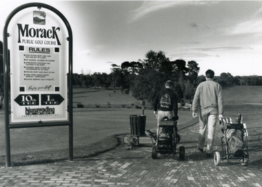
Photograph, Morack Public Golf Course, 1994
... Morack Public Golf Course...morack golf course...Morak Golf Course opened to the public on Sat. 8th May...Black and white photograph of the Morak Public Golf Course... Mitcham melbourne Photograph Photograph Morack Public Golf Course ...Morak Golf Course opened to the public on Sat. 8th May, 1976. Comprising a 9-hole course it was sited north of Burwood Road (now Burwood Highway) and between Morak Road and the Dandenong Creek.Black and white photograph of the Morak Public Golf Course, Vermont South. Large sign on left and two golfers heading out on right. 1994morack golf course -
 Whitehorse Historical Society Inc.
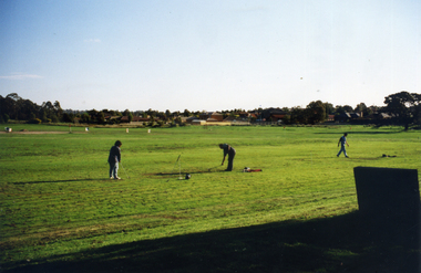
Photograph, Morack Golf Course, C1970
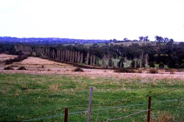
... Morack Golf Course...morack golf course...In 1970, the area now known as the Morack Golf Course... in the development of the Morack Golf Course. Overview of a hole plus white... Mitcham melbourne Photograph Photograph Morack Golf Course Two ...In 1970, the area now known as the Morack Golf Course was rezoned from 'Rural' to 'Public Open Space'. This allowed planning to go ahead and by 1973 sufficient land had been acquired by the Melbourne and Metropolitan Board of Works. The course was first open on 8 May 1976 as a nine-hole course. This was extended to 15 holes by January 1980, and to eighteen holes by 1981.Two coloured photographs a-b of the early days in the development of the Morack Golf Course. Overview of a hole plus white patches indicating where trees have been planted. Some people practicing.morack golf course -
 Bendigo Historical Society Inc.
Slide - Peter Ellis Collection, the Whipstick and Eucalyptus Oil Production, Solomon Gully Reserve Quarry Hill, Quarry Hill Golf Course Extensions Some history of the Whipstick, 1970-1990
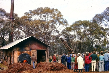
... Production, Solomon Gully Reserve Quarry Hill, Quarry Hill Golf...quarry hill golf course... Hill Golf Course Extensions Some history of the Whipstick...., Solomon Gully Reserve Quarry Hill, Quarry Hill Golf Course ...When the numerous gold mines declined in production, the eucalyptus oil industry became an important source of work. The first eucalyptus oil producer in Bendigo was a chemist called Richard Sandner who operated a plant and refinery in Bridge Street from 1876. By 1900, many other distillers operated on the northern edge of Bendigo and in the Whipstick. In 1926, the Forest Commision established a eucalyptus distillery at Gunyah in Wellsford State Forest. See the Wellsford Forest Note for more information. Today, there are just two eucalypt distilleries operating in Bendigo. Most of the world’s eucalyptus oil is now produced overseas. SOLOMON GULLY CIRCUIT WALK - Solomon Gully Nature Conservation Reserve. Rangers say this is a great place to see heaps of Bendigo Waxflowers. A 1.5km, unsurfaced track. It is rough and steep in places, but suitable for families. Closed shoes with a good drip are recommend. The track is popular with families and runners. There is parking available off Burnside St (opposite Quarry Hill / Bendigo Lawn Cemetery).Peter Ellis Collection, t16 slides of the Whipstick and Eucalyptus Oil Production, Solomon Gully Reserve Quarry Hill, Quarry Hill Golf Course Extensions Some history of the Whipstick.history, bendigo, peter ellis collection, whipstick bendigo, bendigo state forests, eucalyptus oil, solomon gully reserve quarry hill bendigo, whipstick hotel shamrock, magetti's wallace reef wine hall, whipstick, frederick the great mine sebastian, quarry hill golf course -
 Whitehorse Historical Society Inc.
Document, Morack Golf Course, 1/04/1993
... Morack Golf Course...Morack Golf Course...Morack Public Golf Course: Marketing Plan. City... Mitcham melbourne Document Document Morack Golf Course Morack ...Morack Public Golf Course: Marketing Plan. City of Nunawading Parks and Recreations Services, April 1993morack golf course, city of nunawading, parks and reserves, abbott, kevin -
 Whitehorse Historical Society Inc.
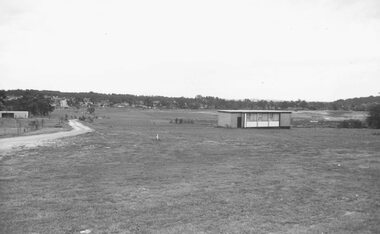
Photograph, Morack Golf Course, c 1976
... Morack Golf Course...morack golf course... view of the Morack Golf Course c 1976. Course was originally 9... Mitcham melbourne Photograph Photograph Morack Golf Course Black ...Black and white photograph of the clubhouse and a general view of the Morack Golf Course c 1976. Course was originally 9 holes in 1976 and extended to 18 holes in 1980morack golf course, city of whitehorse, parks and reserves -
Whitehorse Historical Society Inc.
Article, Strategy for golf course, 1993
... Strategy for golf course...morack golf course...Falling attendances at Morack Golf Course and budget... Mitcham melbourne Article Article Strategy for golf course Falling ...Falling attendances at Morack Golf Course and budget shortfall of $20,000 has forced Nunawading Council to implement a range of marketing strategies to boost attendance and improve the viability of the course.Falling attendances at Morack Golf Course and budget shortfall of $20,000 has forced Nunawading Council to implement a range of marketing strategies to boost attendance and improve the viability of the course.Falling attendances at Morack Golf Course and budget shortfall of $20,000 has forced Nunawading Council to implement a range of marketing strategies to boost attendance and improve the viability of the course.golf, city of nunawading, morack golf course -
Whitehorse Historical Society Inc.
Pamphlet, Morack Public Golf Course, c1985
... Morack Public Golf Course...Morack Golf Course...Pamphlet describing the Morack Public Golf Course... Mitcham melbourne Pamphlet Pamphlet Morack Public Golf Course ...Pamphlet describing the Morack Public Golf Course in Vermont South.Pamphlet describing the Morack Public Golf Course in Vermont South. Its history is outlined and its proposed development. Course maintenance and watering systems are described. The verso is a detailed plan of the course.Pamphlet describing the Morack Public Golf Course in Vermont South. morack golf course, dandenong valley metropolitan park -
 Whitehorse Historical Society Inc.
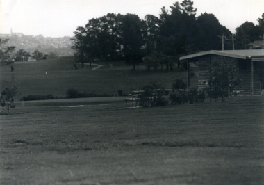
Photograph, Morack Golf Course - clubhouse, c 1976
... Morack Golf Course - clubhouse...morack golf course... at the Morack Golf Course seen from the final hole. Course... Mitcham melbourne Photograph Photograph Morack Golf Course ...Black and white photograph showing the clubhouse at the Morack Golf Course seen from the final hole. Course and clubhouse opened in 1976 as 9 holes, later extended to 18 holes in 1980. c1976morack golf course, city of nunawading, parks and reserves -
 Whitehorse Historical Society Inc.
Photograph, Morack Golf Course, c 1976
... Morack Golf Course...morack golf course...Black and white photograph of the Morack Golf Course... Mitcham melbourne Photograph Photograph Morack Golf Course Black ...Black and white photograph of the Morack Golf Course looking south to the final holes with the original club house on the right. Course opened as 9 holes in 1976, extended into 18 holes in 1980. c 1976morack golf course, city of nunawading, parks and reserves -
 Greensborough Historical Society
Newspaper Clipping, Diamond Valley Leader, Golf course chopped up, 27/07/2016
... Golf course chopped up...bundoora park golf course...Parts of Bundoora Park Golf Course were damaged by vandals.... Plenty Lower Plenty melbourne Newspaper Clipping Golf course ...Parts of Bundoora Park Golf Course were damaged by vandals.News clipping, black text bundoora park golf course, vandalism -
 Greensborough Historical Society
Slide - Photograph, John Ramsdale, Lower Plenty and Rosanna Golf Course: Slide 111, 1990s
... Lower Plenty and Rosanna Golf Course: Slide 111...rosanna golf course... Golf Course to right...Photograph Slide Lower Plenty and Rosanna Golf Course ...Photograph shows a rural scene in Lower Plenty and Rosanna Golf Course to rightPart of the John Ramsdale collection of slides and audio visual material.Colour photograph scanned from slide.No maker's marks. No caption on slide.lower plenty, rosanna golf course -
 Greensborough Historical Society
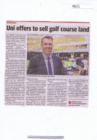
Newspaper Clipping, Diamond Valley Leader, Uni offers to sell Strathallan Golf Course land, 30/08/2017
... Uni offers to sell Strathallan Golf Course land...strathallan golf course... Golf Course land to Darebin Council after years of speculation... to sell Strathallan Golf Course land News article 1 page, black ...La Trobe University has offered to sell the Strathallan Golf Course land to Darebin Council after years of speculation over the future of the Bundoora site.News article 1 page, black text, colour image.la trobe university, strathallan golf course, darebin council -
 Phillip Island and District Historical Society Inc.
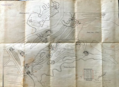
Map, Map of Summerland Golf Course, 15/12/1927
... Map of Summerland Golf Course...Summerlands Golf Course.... Sampbell. It consisted of a housing estate, guest house and golf...-island-and-the-bass-coast Map Map of Summerland Golf Course ...Summerlands Estate was created in the 1920s by A.K. T. Sampbell. It consisted of a housing estate, guest house and golf course. This area was acquired and all buildings, roads etc removed by the Victorian Government in the 1980s for a nature reserve for the penguins. This is believed to be the only time in the world when humans have been removed to benefit nature. HistoricalPurple leather covered fold out linen map with hand drawn diagram of the topography, layout of golf holes and club house Broken sand dunes, rough sandy hills, grassy hills and mounds, Swan Lake, Par for nine holes 34, Scratch score for nine holes 36, Drawn by A. Russell 12/12/1927summerland estate, summerlands golf course, a.k. t. sampbell, map, penguin reserve -
 Kiewa Valley Historical Society
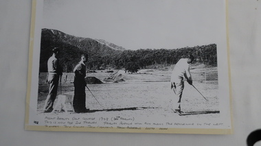
Photo - Golfers at Mt Beauty Golf Course
... Photo - Golfers at Mt Beauty Golf Course.... on a rudimentary course which was the fore runner to the beautiful golf...Hand written at the bottom of the photo: "Mount Beauty Golf... - Golfers at Mt Beauty Golf Course. Photo of 3 men playing golf ...This photograph is one of the first photos of golfing in Mt Beauty. It is dated 1948 and it pictures three high-profile Kiewa Hydro Electric Scheme staff members having a hit of golf on a rudimentary course which was the fore runner to the beautiful golf course we enjoy today. This photo may have been published in one of the SECV magazines.Jack Giniff, Jack Ormerod and Lloyd Dunn were well known on the K.H.E.scheme. The photo shows how quickly community facilities were organised to provide sporting opportunities for the 4000+ workforce.Photo of 3 men playing golf copied from the original onto photo-quality paper in an enlarged form.Hand written at the bottom of the photo: "Mount Beauty Golf Course 1948 (7th Fairway). This is now the 2nd Fairway. Fairway Avenue will run along - the fenceline on the left. Players: Jack Giniff, Jack Ormerod, Lloyd Dunn." Note: "Jack Andrews" crossed out.golf at mt beauty, sport and recreation -
 Kiewa Valley Historical Society
Photograph Farm Land, Mount Beauty Acreage before Golf Course, Circa 1950
... Mount Beauty Acreage before Golf Course..., before the laying of a golf course, for use by the construction... for construction of golf course. Land used, before establishment... Farm Land Mount Beauty Acreage before Golf Course Black ...This photograph is a "snap shot" in time circa 1950s detailing the rural environment before the effects of the Kiewa Valley Hydro Scheme altered the basic rural setting of the valley. The golfing fairway was being mapped out on previous grazing land, before the laying of a golf course, for use by the construction workers and auxiliary administration employees of the Victorian State Electricity Commission. This photograph details a dramatic period in time which saw an enormous change to the exclusively rural area of the Kiewa Valley region in the mid 1900s. This change presented both physical and mental challenges to the existing quiet rural inhabitants of the valley. The State of Victoria had to make adjustments to the changing demands imposed by population and industrial expansions. The development of cleaner energy supplies to a growing population has its downside ,which ever way the intrusion into the "natural" landscape is made.Black and white photograph detailing surveyor posts for construction of golf course. Land used, before establishment of the Mount Beauty Village, as farming/grazing cattle and viewed towards Mount Bogong and its Alpine ranges. The photo is on 200gms paper and not on photographic paper.nilmount beauty in the 1940s - 1950s, grazing in the kiewa valley, sec victoria -
 Southern Sherbrooke Historical Society Inc.
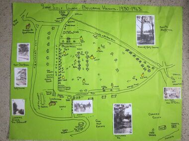
Photograph - 9 hole golf course-Belgrave Heights 1930-1943 map
... 9 hole golf course-Belgrave Heights 1930-1943 map.... Photographs attached, including a view of the golf course, Fern Glade... golf course-Belgrave Heights 1930-1943 map Photograph Hand ...Hand drawn map of Belgrave Heights and its 9 hole golf course, between 1930 and 1943 created by Betty de Coite nee Woods, who holidayed in the area with her family. Map drawn in marker. Photographs attached, including a view of the golf course, Fern Glade Tracks, Lockwood Rd, the dam at Marama Rd corner, The Crescent, the path near the club house, and a wagon near golf course. These photos were taken by members of the Woods family. Map highlights Lockwood House at the corner of Lockwood Rd, the 9 hole golf course, and Sunnyside guesthouse. Club house at Lockwood Rd is later the site of the Convention Centre. Above club house is Fred and Ruby Cook's House. -
 Kew Historical Society Inc
Photograph - Golf course viewed from East Kew, 1940s?
... Golf course viewed from East Kew...Latrobe Golf Course... but possibly 1930s. Kew (Vic.) Latrobe Golf Course ...Landscape photograph of Kew and Fairfield. Undated but possibly 1930s.View of Latrobe Course from the Kew side of the River Yarra. River in middle foreground. Aged pine tree central foreground. Inscribed reverse: "M Holmes"kew (vic.), latrobe golf course -
 Ballarat Heritage Services
Photograph, Nucolorvue, First Fairway of Golf Course, Hepburn, 1957
... First Fairway of Golf Course, Hepburn...Hepburn Golf Course...The first course at the Hepburn Golf Club.... Office goldfields Photograph First Fairway of Golf Course ...Daylesford is a tourist town in Central Victorian, known for its mineral water springs.The first course at the Hepburn Golf Club.Daylesford, Victoria, Australia This famous holiday resort is famous for its up-to-date facilities, as well as for its natural attractions. The mineral Springs are renowned for their high medicinal elements. The visitor finds ample to amuse, in excellent fishing, boating, Boating, Swimming, golfing, hiking and riding. The district provides a wide range of typical Australian bush scenery, and the altitude of 2,000 feet above sea level as a tonic effect on all. Daylesford has modern hotels, guest houses, shops and places of amusement, also many other places of interest within short travelling distance. Bendigo, 50 miles, Ballara 30 miles, and Melbourne 75 miles, bring Daylesford within easy reach of many parts of Victoria. daylesford, fairway, hepburn golf course -
 Southern Sherbrooke Historical Society Inc.
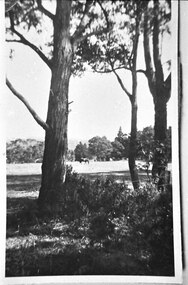
Photograph - Trees and horse at golf course
... Trees and horse at golf course...Photograph of a paddock at the golf course, Lockwood House... and horse at golf course Photograph Photograph of a paddock ...Photograph of a paddock at the golf course, Lockwood House. Between the trees in the foreground, a horse can be seen grazing in the distance. A wire fence can be seen in front of some trees on the right side. Probably taken by Betty de Coite nee Woods or her parents. -
Glen Eira Historical Society
Document - Sunny Hill Golf Course, North Road, Carnegie
... Sunny Hill Golf Course, North Road, Carnegie... for Mr Alston’s payment of interest in the golf course known... VIC 3162 melbourne Sunny Hill Golf Course, North Road ...This file contains two items A letter that is a receipt for Mr Alston’s payment of interest in the golf course known as ‘Sunny Hill’ North Road Carnegie, dated 06/12/1938 A written a rewritten note by Felicitie Campbell from notes and memory of a phone conversation, the informant being Gordon Alston, on the history of the golf course, undated.alston mr, golf courses, ‘sunny hill’, north road, carnegie, sports, recreations, golf clubs, clubs, associations, organisations, societies, leisure, cultural events, cultural activities, sports equipment, recreations equipment, kiosk, cultural structures, cultural establishments, parks, reserves, playing fields, sports people, goodwilland equipment, koornang road, alston gordon, rsl, rnra -
 Park Orchards Community House
Photograph, Photocopies of description of the Park Orchards golf course, 1935
... Photocopies of description of the Park Orchards golf course...Taken from "Golf Courses of Victoria" by Kitty McEwan... golf course Taken from "Golf Courses of Victoria" by Kitty ...Taken from "Golf Courses of Victoria" by Kitty McEwan, edited by WA Shut, published by the Sun News-Pictorial. Dated 1935. -
 Ringwood and District Historical Society
Photograph, Ringwood Golf Course, Canterbury Road. 1973
... Ringwood Golf Course, Canterbury Road. 1973...Written on backing sheet, "Golf course Canterbury Rd. 1973... Road Ringwood North melbourne Photograph Ringwood Golf Course ...Written on backing sheet, "Golf course Canterbury Rd. 1973. Building formerly Eng. Drafting Office behind old town hall." -
Whitehorse Historical Society Inc.
Article, Disability farm in limbo, 2013
... Morack Golf Course...The site suggested is near Morack Golf Course.... is near Morack Golf Course.... at Morack Road. The site suggested is near Morack Golf Course ...Doubts have bee raised about the suitability of an alternative site for the NADRASCA farm which is part of the Healesville Freeway Reservation at Morack Road.Doubts have bee raised about the suitability of an alternative site for the NADRASCA farm which is part of the Healesville Freeway Reservation at Morack Road. The site suggested is near Morack Golf Course.Doubts have bee raised about the suitability of an alternative site for the NADRASCA farm which is part of the Healesville Freeway Reservation at Morack Road. nadrasca, healesville freeway reservation, morack road vermont, koedyk, gus, leane, shaun, morack golf course -
 Greensborough Historical Society
Slide - Photograph, John Ramsdale, Rosanna Golf Course: Slide 74, 1990s
... Rosanna Golf Course: Slide 74...Photograph shows the Rosanna Golf Course at Lower Plenty....Photograph Slide Rosanna Golf Course: Slide 74 Colour ...Photograph shows the Rosanna Golf Course at Lower Plenty.Part of the John Ramsdale collection of slides and audio visual material.Colour photograph scanned from slide.No maker's marks. No caption on slide.rosanna golf club, lower plenty, golf courses -
 Malmsbury Historical Society
Photograph (Item), B/W Photo Malmsbury Golf Course C1920, Malmsbury c1920
... B/W Photo Malmsbury Golf Course C1920, Malmsbury c1920...Associated with - Malmsbury Golf Club Buildings - Golf...-ranges Photograph Photograph B/W Photo Malmsbury Golf Course ...Associated with - Malmsbury Golf Club Buildings - Golf Course People - "Spencer, Peter" -
 Ringwood and District Historical Society
Photograph, View north from Avery Court over valley of the golf course. North Ringwood 1981
... View north from Avery Court over valley of the golf course... Avery Court over valley of the golf course. Tortice Drive... Court over valley of the golf course. North Ringwood 1981 ...Written on back of photograph, "24/8/81. View north from Avery Court over valley of the golf course. Tortice Drive passes the end of Avery Crt, 75 metres behind the camera". -
 Greensborough Historical Society
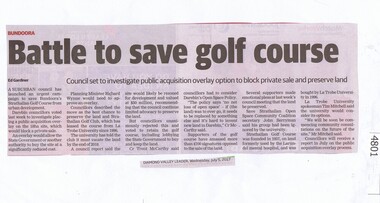
Newspaper Clipping, Diamond Valley Leader, Battle to save golf course, 05/07/2017
... Battle to save golf course... Bundoora's Strathallan Golf Course from urban development.... golf course News article 1 page, black text. A suburban council ...A suburban council has launched an urgent campaign to save Bundoora's Strathallan Golf Course from urban development.News article 1 page, black text.strathallan golf club, darebin council, bundoora -
 Beaufort Historical Society
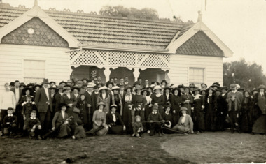
Photograph, Beaufort Golf Course Pavilion 1913
... Beaufort Golf Course Pavilion 1913...Opening of new pavilion at the Beaufort Golf Course in June... Photograph Beaufort Golf Course Pavilion 1913 Black and White ...Opening of new pavilion at the Beaufort Golf Course in June 1913. Architect E J Muntz. Built by Stevenson Bros. for 61 pounds. The links were laid out by renowned designer R Banks. Early sporting club in BeaufortBlack and White Photograph of golfers outside the new pavilionbeaufort, beaufort golf club, beaufort sports club